February 2008 Mount Kilimanjaro Trip
The trip commenced in Oakland, California at 12:15p (UTC/GMT -8) when I left for BART. I arrived at Le Jacaranda Hotel in Arusha, Tanzania on 14 February 2008 at 7:30p (UTC/GMT +3), over 44 hours later. During that time I:
- Learned several common Swahili words and phrases
- Visited a branch of the Rijksmuseum inside Amsterdam Airport Schiphol
- Looked through nearly every shop in the departure area
- Watched The Simpsons Movie
- Fed Giraffes at the Langata Giraffe Center in Nairobi, Kenya
- Sat in traffic in central Nairobi
- Walked across the border between Kenya and Tanzania at Namanga
Ispent most of the day practicing my Swahili, telling half of Arusha where I was from and that I was going to Kili tomorrow. If you don't look and act like a local, it's hard to walk very far in the main part of the city without being accosted by someone selling banana leaf paintings, batiks and/or asking you to visit a curio shop. Mange from Good Earth Tours also stopped by and provided some additional information about the trek.


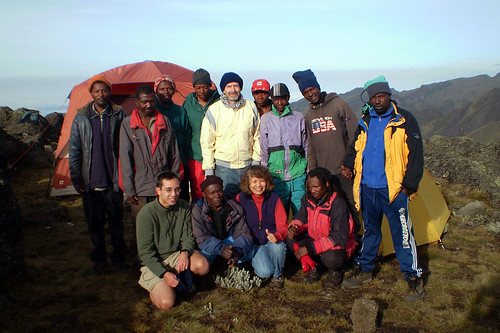
Our guide, Godlisten, met us at 0800 outside the hotel. We rented some heavy duty vinyl ponchos as the plastic ones we had were deemed too flimsy. A few members of the crew, Tuamaini and Augustine were also in the van. It took an hour or so to make it to Machame Gate. Along the way we picked up Nyambo, another assistant guide and more porters. It took nearly another hour to get all the weight distributed and the paperwork squared away, so we began our ascent around 1100.
The elevation at Machame Gate is ~6000ft and the first night's camp is 7+mi away at ~10,000ft. About 2 hours into the hike, it started to rain. 15 minutes later we had to break out the ponchos as it started raining in earnest. Box lunches had been prepared for us with chicken, bread, potato chips, nuts and a chocolate bar. We ate them standing under a tree.
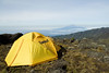
Once we made it to camp, we discovered our bags had gotten wet and many articles of clothing and my sleeping bag were wet. The rain had stopped, but there weren't enough hours of daylight left to dry them so they'd have to wait until tomorrow. The only other thing of note are the bathrooms. They look like classic latrines and vary in condition from somewhat bearable to downright vominous and were a constant topic of discussion for the rest of the trip.
This day's hike was the shortest, distance wise, of the whole trek at just over 3mi with ~2,600ft of elevation gain. The trail was fairly steep, similar to Mission Peak. Our clothes had not dried much overnight, so we hoped the weather would hold up long enough for them to dry at Shira Camp.
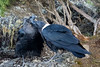
We had another box lunch and a few White Necked Ravens visited us looking for food (they ended up with my corn muffin). It didn't rain at all, though sets of clouds would roll by constantly. Even though the sun never seemed to be out for more than a few minutes at a time during our hike, the porters had made it to camp and placed our clothes out long enough for them to dry.
Godlisten split our group up this morning. I went ahead with Tuamaini, one of the assistant guide/porters. He has unbelievable energy and stamina. With a ~40lb bag balanced perfectly on his head and a daypack he set an exhausting pace, only stopping when I asked for a break, "simama tafadhali".
This portion of the trek was labeled an "acclimatization day" as over the course of ~6mi, we went from ~12,600ft to ~15,200ft and then down to ~13,000ft. We had lunch at Lava Tower Campsite, the high point of the day and then scurried down to Barranco Camp. I believe I was the first non-African person there and I promptly laid down in the tent.


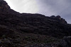
Again I went ahead with Tuamaini; however, today I set the pace so as not to be exhausted upon reaching Barafu Camp. In <24 hours, around midnight, I would be embarking on my summit attempt. After scaling the Barranco Wall, we made our way to Karanga Valley. At one point the porter in front of me lost his balance and dropped a large sack down the trail. While other porters were chuckling, a porter behind me also lost his balance and his cargo rolled by me down the hill as well.
This stage of the trek was a bit long, over 5mi and had some up and down to it (~13,000ft to ~13,900ft to <13,000ft to >15,000ft). This was disheartening at times and quite tiring due to the altitude as the air pressure during the hike is <60% relative to sea level. We had lunch at Karanga Camp and I arrived at Barafu Camp shortly after 2p. I reorganized my daypack in preparation for the summit attempt, ate and took a nap. Nyambo woke us up at 2300 so we could have a snack and some tea before trudging off towards Uhuru Peak.
I left camp around 0010 with Nyambo and Tuamaini and we headed off under the light of a nearly full moon. I was wearing two pairs of socks, long underwear, pants, a t-shirt, a long sleeve shirt, a pullover, a heavy jacket, a wool hat, glove liners and thick gloves. I had 4 liters of water, a head lamp, another pullover, a scarf and a balaclava in my backpack along with my GPS, digital camera and a disposable film camera in case that stopped functioning at the summit.
Most other people were using their headlamps so it was easy to spot them from a distance as they trudged up the mountain. There was a constant wind that would stay with us throughout the night. We walked for an hour and a half without stopping and then I asked for a break. The GPS read 16,383ft so we had covered more than 25% of the elevation gain. I noticed that the mouthpiece of the hose coming out of my platypus was starting to freeze up. It, along with the water in the supposedly insulated tube, would completely freeze later on.
After sticking a warmer in each of my gloves we tramped off again. The town of Moshi was lit up and visible for most of the hike. I only made it about an hour without needing a break this time, and when I checked the GPS it read 17,492ft. We'd covered about 55% of the elevation gain. I had lost most of the warmth in my fingers at this point (in spite of the warmers) and was constantly squeezing/releasing my trekking poles to increase circulation. My toes were also quite painful, but it was harder to keep wiggling them while walking. They eventually went numb, while I was able to keep my fingers in the painful, but at least I know they're there, state.
The rest of the trek to Stella Point (18,760ft and supposedly only a 45min or so walk from Uhuru Peak) consisted of me asking to stop more and more frequently and devolved into me taking X number of steps, then pausing for Y number of breaths. X:Y was probably around 25-30:5-10. At one point when I thought we should be getting close to Stella Point I asked Nyambo how much further it was. He replied 1 hour. That was a bit disheartening as it was already 0510 and I figured we were on pace to be there before 0530 so as to get to the summit for the sunrise.
I'm not sure if he was joking or thought I was asking how far it was to the summit, but less than 5 minutes later, he pats me on the shoulder and says, "Stella Point in 2 minutes boss." I took a break at Stella Point and pulled my insulated water bottle out as I had been unable to drink from my platypus for the last few hours. There were some people lying on the ground and others who were walking with the support of two other people. It definitely took more effort to breathe up here, but I wasn't feeling any ill-effects.
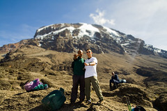
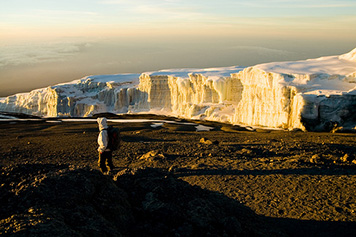
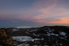
The steepness of the grade lessened quite a bit the rest of the way to the summit. I could see the first signs of the sunrise and eventually made it to Uhuru Peak, elevation 19,340ft, air pressure 40% that of sea level, temperature 5F, wind constant at probably 30mph with stronger gusts, around 0620. We had our photo taken by the sign at 0623 so I use that as my official summit time. The sun had popped up over the horizon and I could see the crater and several of the glaciers/ice fields. They still look pretty sizable e.g. it still feels like you're surrounded by glaciers, even though it's predicted they'll be gone by 2020.
The decent back to Barafu took about and hour and a half. It was nearly as exhausting as the ascent. All the porters shook my hand and congratulated me and after resting for a bit, I packed up my stuff and everyone continued down to Mweka Camp, another ~4.5mi away at ~10,200ft.


TThe final stage was a 6mi jaunt to 5,384ft. We tipped the crew that morning and headed down. At the bottom we signed our last log book, I received my "golden certificate" and we all piled into a van. We dropped off some of the crew in Moshi and then were dropped off at our hotel in Arusha. I finished the last of my postcards and did a bit of shopping, this time doing a better job of avoiding the touters.
The next day we took a walk to the outskirts of town to see what an Arusha supermarket looked like and then hopped back on the shuttle to Nairobi. The rest of the journey was pleasant and uneventful, the flights from Nairobi to Amsterdam to San Francisco were on time.